Port-City Perspectives


Infographic of the Comparative Analyses on the two Sets of Mental Maps

In the Minds of People: The Case of Rotterdam

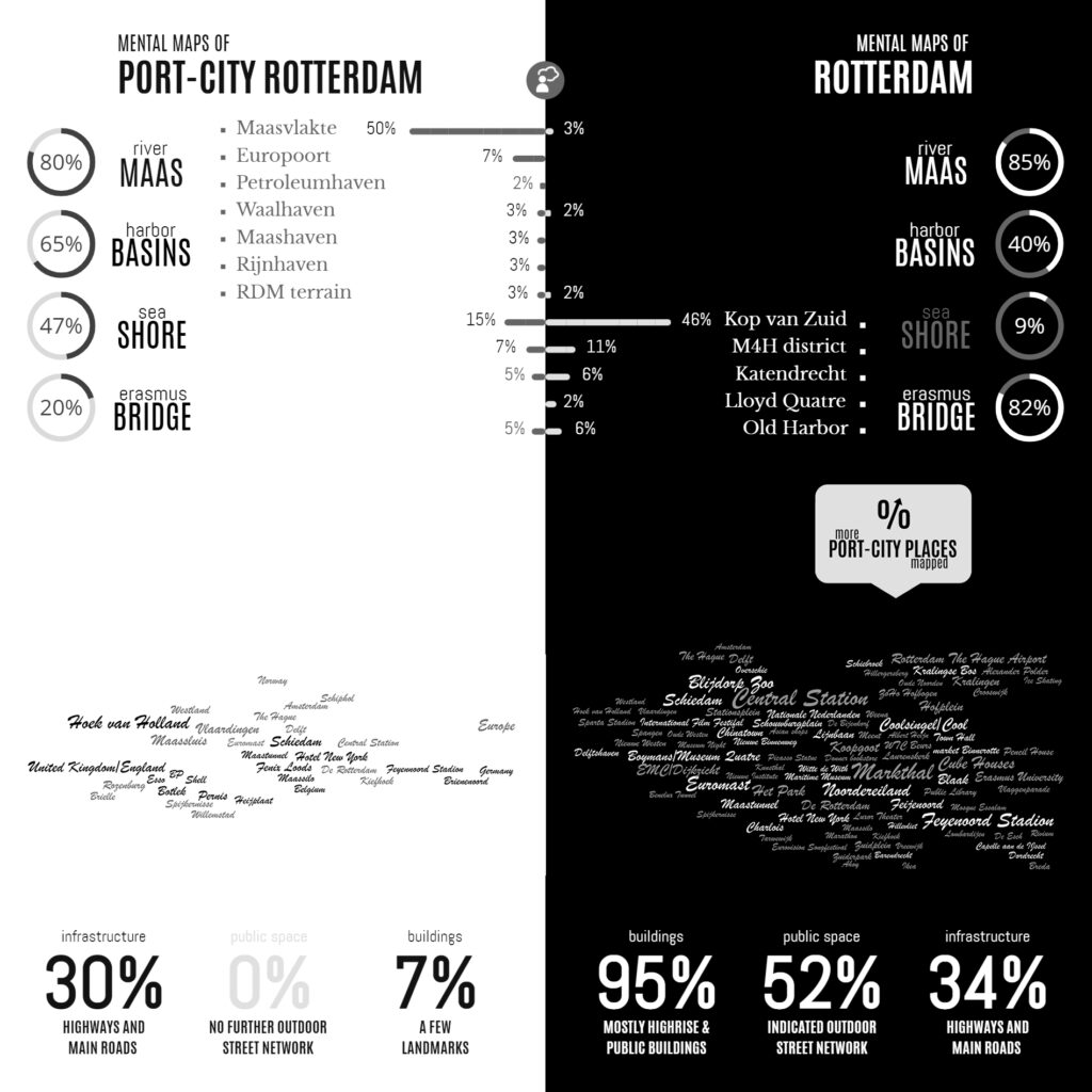
Following the geographical ‘Any-Port Model’, urban design has stipulated and enforced the disunion of port and city over the recent decades. In conjunction with other disciplines, the emphasis has been laid at the dislocation of production activities in favour of logistic-productive dynamics. At the same time, the professional focus was on the urban areas where most citizens are. While this practice has led to the redevelopment of abandoned harbour areas too, foremost the approach stimulated stronger physical boundaries between lived city and the remaining and new harbour areas. This article describes the application of the dominant model in Rotterdam over the recent decades, on the basis of literature review, and, it confronts this with the concepts of Rotterdam which are in the minds of professionals-in-training, through the method of ‘mental mapping’. On the one hand, mainly harbour areas are memorised when respondents are asked to draw the port-city of Rotterdam, even though its efficient port infrastructure makes public space in these areas rare, and most harbours are located behind inaccessible borders. On the other hand, civic areas, which have a refined network of public spaces and are places for daily life, reveal also all kinds of tangible and intangible signs and symbols related to characteristics of the port-city when memorised; even more. Various elements, linked to water-land or the flows of goods, people, and ideas, dominate the minds of the people when they think of Rotterdam in general. These outcomes reconfirm the unique unity of port and city and provide a way to find an alternative or supplementary model accepting the complex nature of port-cities.

Read:
Harteveld, Maurice (2021) In the Minds of People: Port-City Perspectives, The Case of Rotterdam, In: European Journal of Creative Practices in Cities and Landscapes (CPCL), Vol. 4, No. 2.

See also:
Maritime Mindsets
Biographies of Places

Stress Reduction and Healing

Rosalie Moesker, an urban designer in training in our team, makes the cross-over to health. As the campus of Erasmus Medical Centre densifies, not only accessibility is at stake, more so, the human experience while traveling. In the city of the future, the medical centre needs new mobility concepts. When we design for these, we can relieve users of worries by reducing urban stress at their arrival, and rethinking public space as a healing environment during stay.


source: TV Rijnmond, Tuesday, November 16, 17:35
Continue reading

Images of Port-Cities

In this video, you will get an explanation on how mental maps help us to (re)imagine port-cities in two steps: First, by explaining generally why people draw what they draw, and second, by explaining how images of port cities, as displayed in mental maps, are rooted and influenced by cultural frameworks of experience, and how they are biased according to the particular background of the beholder.

This educational video is part of the course Re-Imagining Port Cities: Understanding Space, Society and Culture available for free via online-learning TUDelft , and at the EdX MOOC platform. ©️ TU Delft, released under a CC BY NC SA license.

See also: the introduction video on Mental Mapping and the full MOOC on EdX: (Re)Imagining Port Cities: Understanding Space, Society and Culture

Mental Mapping

In this video, you hear more about the concept of a ‘mental map’, the mapping method, or the underlying theory, and why it matters, and how you can use it to educate others.

But before you watch, choose a port-city, and do a small exercise: sketch a map of your port city from memory.

If you have trouble getting started, just imagine you are walking through your port city. What would you see on the way? Are there specific elements or landmarks that stand out? Those are the kind of elements to include in your map. And don’t worry about getting all the details exactly right, it is just a sketch…

  • Do this all by yourself: close your laptop, put your tablet to sleep, turn your smartphone around, do not consult any books, and do not talk to anyone…
  • Draw your map on a blank, unlined sheet of paper, and don’t spend more than ten minutes on this task!

    Don’t worry about details; this map is not meant to be perfect!

    This educational video is part of the course Re-Imagining Port Cities: Understanding Space, Society and Culture available for free via online-learning TUDelft , and at the EdX MOOC platform. ©️ TU Delft, released under a CC BY NC SA license.

    See also: the subsequent video on Images of Port Cities and the full MOOC on EdX: (Re)Imagining Port Cities: Understanding Space, Society and Culture

  • Digital, Virtual, and Physical

    Physical Public Space X Virtual Space

    Urban designers and landscape architects observe physical public spaces as spaces that are able to accommodate accidental meetings, reveal places’ identity, provide impulsive on-the-spot choices, and allow human-nature interaction through wind or sunshine. However, the recent crisis unfolds the intertwining between physical public space and virtual space. During two days, we focus on the shift of the planner’s outlook on physical public space and virtual space.

    Join the webinars!
    When: Thursday, November 5 and 6, 9.00am – 6.00pm CET
    > Registration


    Bits of Public Space 3.0: Trailer, published by Polis on YouTube
    Video credits: Ioanna Kokkona

    Continue reading

    Mapping Maritime Mindsets: Mental Maps

    Imagine: You are asked to draw a port city from memory. What would you put on paper? Do you think of harbours? Water, docks, cargo, moving loads, and ships? If your drawing shows these elements, don’t be surprised. Sixty-five graduate students also took on the challenge. In answering: “draw the port city of Rotterdam by mind”, the drawings of the participants (fig.1) displayed exactly the above features. Of course, this makes sense. A port just happens to be a place on the water in which ships shelter and dock to (un)load cargo and/or passengers. A harbour is a sheltered place too, and in its nautical meaning, it is a near-synonym for sheltered water, in which ships may dock, especially again for (un)loading. So, all the above linguistic lemmas are there and all these are connected to imaginable objects.

    Keep reading on Port City Futures | Leiden•Delft•Erasmus

    Courses run Online On-Distance

    In-class on-campus settings have been cancelled due to the situation induced by the COVID-19 virus. Participants of the courses have been distributed over a wide variety of time zones (from -11h to +8h). As a consequence, the graduate course on ‘People, Movement & Public Space’ and graduate design studios on ‘Architecture and Urban Design’ and ‘The City of the Future’ run fully online and on-distance for its 100 registred Delft students and exchange students. This includes an on-demand video lecture series and small weekly assignments that go along. Remote education includes sharing info, presentations, student peer-review, and, in the studio, tutorials, workshops and whiteboard sessions.

    The course on ‘People, Movement & Public Space’ provides an overview of vested theories and cutting edge applied research on people’s movement, urban vitality, and public space. This includes seminal works and continues by updating understanding by today’s challenges. The role of citizens and designers in shaping vibrant urban public space is explored through readings, film, and active discussions among participants. The course material, provided in a virtual learning environment, comes alive through active discussions and the direct application of theories in analysing real urban settings.

    In the interdisciplinary Master’s design studios, participants discuss and overlap their updates and translate this to urban analytical approaches in a group setting. These approaches are presented to peers and a broad team of interdisciplinary supervisors at least twice a week. The collaborate focus is particularly on the consequences of urbanisation for the major foundations of the city of the future – urban infrastructure and public space –, and with this focus, the ultimate aim is to envision an illustrative and inherently experimental design within the larger set of visions produced by fellow students. In these designs, students and staff are interested on one hand to the urban intervention in the built environment and its effect on architecture, and on the other hand to the architectural treatment of the city and its effect on urban design.

    People, Movement & Public Space

    Improving our ways to urbanise and innovate urbanisation processes are needed in order to meet the UN Sustainable Development Goals, hence deliver the Quito New Urban Agenda promise. During the Future Days event, participants renewed the listing of urban topics. They bridge the gaps between academics and practitioner. They have presented much more evidence-based policies at the global level and with local examples and test-beds. And, they generated a better understanding of the driving forces of urbanisation and of the needs for better regulating the processes.

    People, Movement and Public Space
    In a keynote at the Future Days 2019 event, themed ‘Legacy and Future of our Cities’, I illuminated the interdisciplinary topic ‘people, movement and public space’, in order to understand assembled complexities of cities which go along with this topic. I introduced a four-step approach: First, a network-theoretical approach in the analyses of path systems, aiming to understand the complex dynamic systems of real cities better. Second, the analyses of personal perspectives on these paths apply more a non-linear approach to understand complex trajectories and interactions in reality. Third, engaged with the human-adaptive approach, analysing the psychology of place helps to understand patterns in the evolutionary inter-subjectivity of being in cities. Lastly, by observing public life, understanding the emergence of life in real cities, and non-equilibria, may be understand from a self-organising approach.
    Continue reading