How to Design Public Space for Maritime Mindsets? That’s a central question in the new Minor ‘Minor (Re)Imagining Port Cities: Understanding Space, Society, and Culture’.
Tag Archives: port cities
Public Health + Public Space
Health is an important societal topic in the Netherlands. In one of the most densely populated countries in the world, healthy living environments reduce diseases, deaths, healthcare costs, and shifts focus from prevention and medicalising on the individual levels to taking care of communities. Still, for example, the air quality in the Netherlands is considered moderately unsafe, resulting in the highest rate of asthmatic children worldwide. The same goes for recordings of diseases related to polluting substances on land and in water. This makes public spaces social determinants of public health. We see similar correlations when it comes to the presence of infectious microbes and parasites, and environmental stress. Especially in world port-cities like Rotterdam unhealthy conditions coincide with unequal socio-spatial patterns. Here the impact on individual health is largely untraceable. Understanding the impact of inherent industrial and human activities on urban areas at the neighbourhood level and crossing it with heterogeneous data sets help us understand the socio-spatial impact of pollution-related and vector-borne diseases on cities. Measuring environmental pollution in public spaces can tell us e.g. more about the impact of air quality on citizens as a group. Statistical time series and cross-sectional data analyses can be applied to generate valid correlations if they are made geo-specific. By using machine learning and AI technologies we cross data on environmental pollution with other heterogenous socio-spatial and temporal data sets. The use of mapping, spatial statistics, and urban narratives including historical data can lead to a better understanding of the lived experience at the local level. Through workshops at the local level and notably in the public spaces of the city, we engage the general public and local decision-makers in discussions on public health using advanced computer models for visualisation. The Rotterdam case study provides insights applicable in other cities internationally.
See: Dutch Research Agenda (NWA) initiative on Public Health and Public Space
Biographies of Places
Today, historiographies seem to have moved away from traditional political and diplomatic histories describing cities towards social and cultural approaches. In general, this current shift of interest follows a Late-Modern turn toward the marginalized and marginalizing evidence, and thus explicit hypotheses are tested, and, among others, unbiased data is collected by current biographers. Still, certain narratives stay manifest. Also in Rotterdam. Here, bifocal narratives on the world port and the cosmopolitan city, and the dichotomy among these territories, remain persistent in the most recent biographies. What is seen in everyday space does not match this ontology generally applied in Rotterdam. To greater extent, as such, the samples of the biographies of public spaces as places help to fulfill the most essential public function of researching and abiding justification, while reinvigorating the critical public present in spaces. By opening up to the multiplicity of narratives, the article ‘The Port-City Portrayed in its Public Spaces: Introducing Micro Biographies of Places’ is able to focus on descriptions of Rotterdam which fall outside the scope of the current conventional. Through the lens of ‘biographies of places’, this study particularly follows the so-called material turn, in difference to stories of lives or narratives on actor networks. Hence buildings and artifacts placed in context, are the principal unit of analysis, for a multidimensional interpretation of urban sites across regions and periods.
The approach is operationalized by linking the urban and architectural design of public space, with studies of urban history, literature, cartography, and other urban humanities. This integrated perspective on port-cities is put forward most recently in a wider variety of projects at the LDE Centre of PortCityFutures, which has been promoted and supported for the approach below.
Harteveld, M.G.A.D. (2021) The Port-City Portrayed in its Public Spaces: Introducing Micro Biographies of Places. In: PortusPlus: the Journal of RETE (Association for the Collaboration between Ports and Cities). Venice: RETE, Vol. 12.
See also:
Port-City Perspectives
Maritime Mindsets
Solving the Dutch Housing Crises

| The Port of Rotterdam as Solution The Dutch housing shortage is manifesting itself on all fronts. There are too few rental properties, but also too few homes for starters, large families, and retirees. Mortgage rates are low, but house prices are skyrocketing. And those who do not qualify for social housing will pay themselves blue. How do we ensure that everyone has the right to a suitable home? . “Anchorman Klaas van Kruistum, Michiel Hulshof of Tertium and Claire van der Meer of the Universiteit van Nederland believe that every complex problem has a solution. And together we use the best of Dutch science to find it!” . In episode 2 of ‘De Oplossers’ of KRO-NCRV, Maurice Harteveld explains how the current harbour areas of Rotterdam could be the game changers in the housing crisis. Do we want to sacrifice the green pastures around the city or the harbour areas with large-scale polluting industries? |
De Rotterdamse Haven als Oplossing De Nederlandse woningschaarste manifesteert zich op alle fronten. Er zijn te weinig huurwoningen maar ook te weinig woningen voor starters, grote gezinnen en gepensioneerden. De hypotheekrente is laag, maar de woningprijzen rijzen de pan uit. En wie niet in aanmerking komt voor een sociale huurwoning betaalt zich blauw. Hoe zorgen we ervoor dat iedereen recht heeft op een geschikte woning? . “Presentator Klaas van Kruistum, Michiel Hulshof van Tertium en Claire van der Meer van de Universiteit van Nederland, denken dat elk complex probleem een oplossing kent. En gebruiken samen het beste van de Nederlandse wetenschap om die te vinden!” . In aflevering 2 van ‘DeOplossers’ van KRO-NCRV legt Maurice Harteveld uit hoe de huidige havengebieden van Rotterdam weleens de gamechangers in de Wooncrisis kunnen zijn. Willen we het groene weiland om de stad opofferen of de havengebieden met de grootschalige vervuilende industrie? |
where:
Episode #2 – Woningtekort
KRO-NCRV, NPO Radio 1
Friday 17 December 2021
.
Listen as podcast: NPO Radio 1 – De Oplossers, or via Spotify, Apple Podcast, Podtail, and Google Podcast.
Cross-Media Website: De Oplossers
More: KRO-NCRV Press Release
Port-City Perspectives
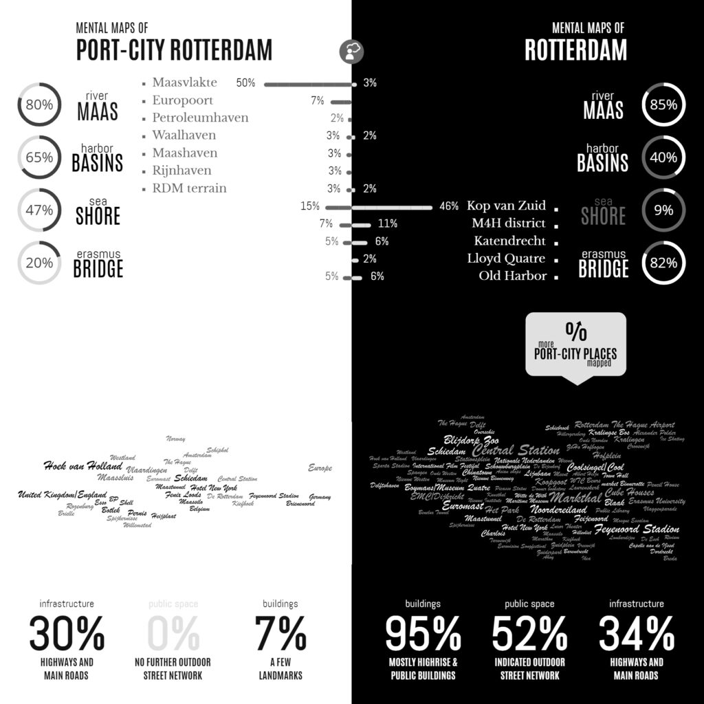
Infographic of the Comparative Analyses on the two Sets of Mental Maps
In the Minds of People: The Case of Rotterdam
Following the geographical ‘Any-Port Model’, urban design has stipulated and enforced the disunion of port and city over the recent decades. In conjunction with other disciplines, the emphasis has been laid at the dislocation of production activities in favour of logistic-productive dynamics. At the same time, the professional focus was on the urban areas where most citizens are. While this practice has led to the redevelopment of abandoned harbour areas too, foremost the approach stimulated stronger physical boundaries between lived city and the remaining and new harbour areas. This article describes the application of the dominant model in Rotterdam over the recent decades, on the basis of literature review, and, it confronts this with the concepts of Rotterdam which are in the minds of professionals-in-training, through the method of ‘mental mapping’. On the one hand, mainly harbour areas are memorised when respondents are asked to draw the port-city of Rotterdam, even though its efficient port infrastructure makes public space in these areas rare, and most harbours are located behind inaccessible borders. On the other hand, civic areas, which have a refined network of public spaces and are places for daily life, reveal also all kinds of tangible and intangible signs and symbols related to characteristics of the port-city when memorised; even more. Various elements, linked to water-land or the flows of goods, people, and ideas, dominate the minds of the people when they think of Rotterdam in general. These outcomes reconfirm the unique unity of port and city and provide a way to find an alternative or supplementary model accepting the complex nature of port-cities.
Read:
Harteveld, Maurice (2021) In the Minds of People: Port-City Perspectives, The Case of Rotterdam, In: European Journal of Creative Practices in Cities and Landscapes (CPCL), Vol. 4, No. 2.
See also:
Maritime Mindsets
Biographies of Places
Maritime Mindsets
Images of Port-City Rotterdam, through the Mental Mapping Methods
This article makes explicit why, at first, we do not usually think beyond water, docks, cargo, moving loads, and ships when we think of port-cities. By reviewing mental maps of port-city Rotterdam drawn by professionals in training, it becomes clear that the adjective ‘port’ modifies the meaning of ‘city’ in such an extent that this echoes in the mind. It does exceptionally when respondents are asked explicitly to draw the ‘port-city’ by mind. Port and city seem to have become conceptual dichotomies. In the case of Rotterdam, the established professional points of views seem to be aligned with this disunion, even though the current trend in practice turns towards a desire to (re)develop the port-city as one. Through similar mental mapping experiments on Rotterdam, yet without adding the label of ‘port-city’ in the question, much richer images of the port-city of Rotterdam are generated. Multi-scalar reviews of such maps help to explicate much more inherited relations between nature and artifice, as well as for example the flows of goods and people. Ultimately, this approach changes the perspectives on the port-city, also for professionals in practice.
Read:
Harteveld, Maurice (2021b) Images of Port-City Rotterdam, through the Mental Mapping Methods. In: Portus, the Online Magazine of RETE (Association for the Collaboration between Ports and Cities), No. 42-2021, Year XXI. RETE Publisher, Venice, ISSN 2282-5789
See also:
Biographies of Places
Port-City Perspectives
Images of Port-Cities
In this video, you will get an explanation on how mental maps help us to (re)imagine port-cities in two steps: First, by explaining generally why people draw what they draw, and second, by explaining how images of port cities, as displayed in mental maps, are rooted and influenced by cultural frameworks of experience, and how they are biased according to the particular background of the beholder.
This educational video is part of the course Re-Imagining Port Cities: Understanding Space, Society and Culture available for free via online-learning TUDelft , and at the EdX MOOC platform. ©️ TU Delft, released under a CC BY NC SA license.
See also: the introduction video on Mental Mapping and the full MOOC on EdX: (Re)Imagining Port Cities: Understanding Space, Society and Culture
Mental Mapping
In this video, you hear more about the concept of a ‘mental map’, the mapping method, or the underlying theory, and why it matters, and how you can use it to educate others.
But before you watch, choose a port-city, and do a small exercise: sketch a map of your port city from memory.
If you have trouble getting started, just imagine you are walking through your port city. What would you see on the way? Are there specific elements or landmarks that stand out? Those are the kind of elements to include in your map. And don’t worry about getting all the details exactly right, it is just a sketch…
Don’t worry about details; this map is not meant to be perfect!
This educational video is part of the course Re-Imagining Port Cities: Understanding Space, Society and Culture available for free via online-learning TUDelft , and at the EdX MOOC platform. ©️ TU Delft, released under a CC BY NC SA license.
See also: the subsequent video on Images of Port Cities and the full MOOC on EdX: (Re)Imagining Port Cities: Understanding Space, Society and Culture
City x Space
In the spring of 2021, the Delft University of Technology, COB Platform of Subsurface Construction, the Environmental Department of the Flemish Government, and the Deltametropolis Association have started a design study exploring the possibilities of integral and multifunctional use of space within highly densified cities. Design consortia from practice have been invited to choose from a number of cases in The Netherlands and Flanders involving spatial bottlenecks in public space, subsurface, and buildings. Seven teams have already started.
Underground Use of Space as a Game-Changer
Due to the convergence of a multitude of tasks and transitions (energy, climate, circularity, mobility) in ever densifying cities, the pressure on public space is increasing. It is especially today because these cities also have to absorb a large share of the housing assignment, following the aims to preserve the rural landscape as well as to reduce the pressure on the current mobility system. However, how much densification is (still) possible for locations that are already overloaded with functions and programs and where the public space – both above ground and below ground level – threatens to silt up and get stuck?
Current and future space claims require careful consideration of the options for using space more effectively and efficiently, with the aim of increasing the ‘spatial efficiency’ of the city in an innovative way.
In the design study, partners focus on a different view of the organisation of urban programmes and transition tasks while they search for new ways of thinking, patterns, and solutions for integral and multifunctional use of space from the cross-section.
The central question:
How can integral and multifunctional use of public space, subsoil, and buildings within a densified urban environment create space and value that contribute to an attractive and future-proof living environment?
The design study has resulted in various spatial designs with visions of the future and implementation strategies. A number of urban locations as case studies are being worked on, namely Ostend, Rotterdam, Amsterdam, Mechelen, Leuven, and Maastricht. For each case study, a multidisciplinary team was selected (in Rotterdam 2) of spatial designers (architects, urban planners, landscape architects), engineers, and the experts required for underground developments such as geo-technicians.
Partners:
Centrum voor Ondergronds Bouwen / COB Platform of Subsurface Construction
Departement Omgeving Vlaanderen / Environmental Department of the Flemish Government
Deltametropolis Association / Vereniging Deltametropool
Mapping Maritime Mindsets: Mental Maps
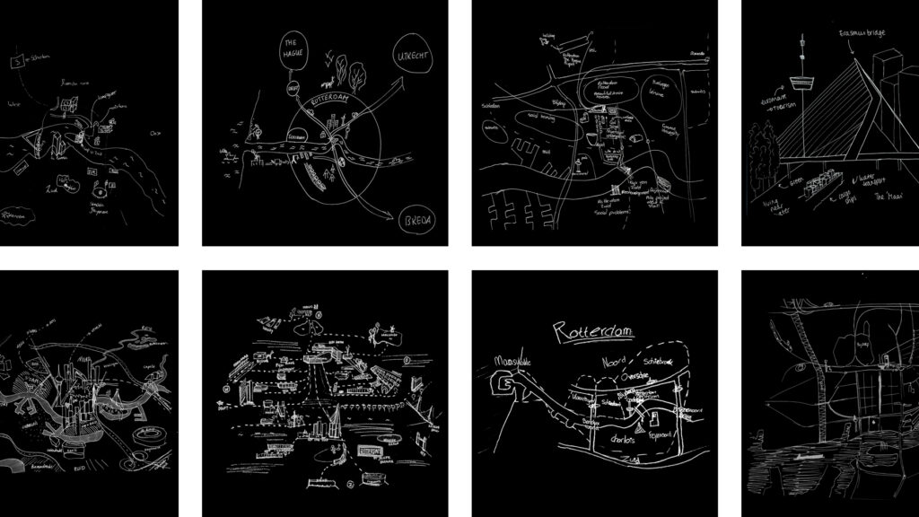
Imagine: You are asked to draw a port city from memory. What would you put on paper? Do you think of harbours? Water, docks, cargo, moving loads, and ships? If your drawing shows these elements, don’t be surprised. Sixty-five graduate students also took on the challenge. In answering: “draw the port city of Rotterdam by mind”, the drawings of the participants (fig.1) displayed exactly the above features. Of course, this makes sense. A port just happens to be a place on the water in which ships shelter and dock to (un)load cargo and/or passengers. A harbour is a sheltered place too, and in its nautical meaning, it is a near-synonym for sheltered water, in which ships may dock, especially again for (un)loading. So, all the above linguistic lemmas are there and all these are connected to imaginable objects.
Keep reading on Port City Futures | Leiden•Delft•Erasmus