Port-City Perspectives


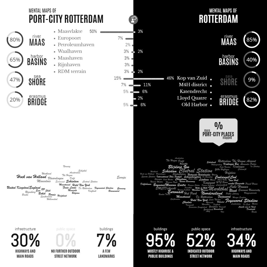
Infographic of the Comparative Analyses on the two Sets of Mental Maps

In the Minds of People: The Case of Rotterdam

Following the geographical ‘Any-Port Model’, urban design has stipulated and enforced the disunion of port and city over the recent decades. In conjunction with other disciplines, the emphasis has been laid at the dislocation of production activities in favour of logistic-productive dynamics. At the same time, the professional focus was on the urban areas where most citizens are. While this practice has led to the redevelopment of abandoned harbour areas too, foremost the approach stimulated stronger physical boundaries between lived city and the remaining and new harbour areas. This article describes the application of the dominant model in Rotterdam over the recent decades, on the basis of literature review, and, it confronts this with the concepts of Rotterdam which are in the minds of professionals-in-training, through the method of ‘mental mapping’. On the one hand, mainly harbour areas are memorised when respondents are asked to draw the port-city of Rotterdam, even though its efficient port infrastructure makes public space in these areas rare, and most harbours are located behind inaccessible borders. On the other hand, civic areas, which have a refined network of public spaces and are places for daily life, reveal also all kinds of tangible and intangible signs and symbols related to characteristics of the port-city when memorised; even more. Various elements, linked to water-land or the flows of goods, people, and ideas, dominate the minds of the people when they think of Rotterdam in general. These outcomes reconfirm the unique unity of port and city and provide a way to find an alternative or supplementary model accepting the complex nature of port-cities.

Read:
Harteveld, Maurice (2021) In the Minds of People: Port-City Perspectives, The Case of Rotterdam, In: European Journal of Creative Practices in Cities and Landscapes (CPCL), Vol. 4, No. 2.

See also:
Maritime Mindsets
Biographies of Places

Images of Port-Cities

In this video, you will get an explanation on how mental maps help us to (re)imagine port-cities in two steps: First, by explaining generally why people draw what they draw, and second, by explaining how images of port cities, as displayed in mental maps, are rooted and influenced by cultural frameworks of experience, and how they are biased according to the particular background of the beholder.

This educational video is part of the course Re-Imagining Port Cities: Understanding Space, Society and Culture available for free via online-learning TUDelft , and at the EdX MOOC platform. ©️ TU Delft, released under a CC BY NC SA license.

See also: the introduction video on Mental Mapping and the full MOOC on EdX: (Re)Imagining Port Cities: Understanding Space, Society and Culture

Mental Mapping

In this video, you hear more about the concept of a ‘mental map’, the mapping method, or the underlying theory, and why it matters, and how you can use it to educate others.

But before you watch, choose a port-city, and do a small exercise: sketch a map of your port city from memory.

If you have trouble getting started, just imagine you are walking through your port city. What would you see on the way? Are there specific elements or landmarks that stand out? Those are the kind of elements to include in your map. And don’t worry about getting all the details exactly right, it is just a sketch…

  • Do this all by yourself: close your laptop, put your tablet to sleep, turn your smartphone around, do not consult any books, and do not talk to anyone…
  • Draw your map on a blank, unlined sheet of paper, and don’t spend more than ten minutes on this task!

    Don’t worry about details; this map is not meant to be perfect!

    This educational video is part of the course Re-Imagining Port Cities: Understanding Space, Society and Culture available for free via online-learning TUDelft , and at the EdX MOOC platform. ©️ TU Delft, released under a CC BY NC SA license.

    See also: the subsequent video on Images of Port Cities and the full MOOC on EdX: (Re)Imagining Port Cities: Understanding Space, Society and Culture

  • Mapping Maritime Mindsets: Mental Maps

    Imagine: You are asked to draw a port city from memory. What would you put on paper? Do you think of harbours? Water, docks, cargo, moving loads, and ships? If your drawing shows these elements, don’t be surprised. Sixty-five graduate students also took on the challenge. In answering: “draw the port city of Rotterdam by mind”, the drawings of the participants (fig.1) displayed exactly the above features. Of course, this makes sense. A port just happens to be a place on the water in which ships shelter and dock to (un)load cargo and/or passengers. A harbour is a sheltered place too, and in its nautical meaning, it is a near-synonym for sheltered water, in which ships may dock, especially again for (un)loading. So, all the above linguistic lemmas are there and all these are connected to imaginable objects.

    Keep reading on Port City Futures | Leiden•Delft•Erasmus

    Democratic, Inclusive, Agential Cities


    This article highlights the dynamics of values in our reasoning on public space. By means of an epistemological study, illustrated by examples in the Dutch city of Amsterdam, it tests the contemporary premises underlying our ways to safeguard the inclusive, democratic, agential city, and, as such, it aims to update our view on public space. The article raises three subsequent main questions: [i] Is the city our common house as perceived from the Renaissance onward, containing all, and consequently are public spaces used by the people as a whole? [ii] Is the city formalising our municipal autonomy as emphasised since the Enlightenment, in an anti-egoistic manner, and in this line, are public spaces owned by local governments representing the people? And, [iii] is the city open to our general view as advocated in Modern reasoning, restricting entrepreneurial influences, and synchronically, is its public spaces seen and/or known by everyone? – Inclusiveness, democracy, and agentiality are strongholds in our scientific thinking on public space and each issue echoes through in an aim to keep cities connected and accessible, fair and vital, and open and social. Yet, conflicts appear between generally-accepted definitions and what we see in the city. Primarily based upon confronting philosophy with the Amsterdam case for this matter, the answering of questions generates remarks on this aim. Contemporary Western illuminations on pro-active citizens, participatory societies, and effects of among others global travel, migration, social media and micro-blogging forecast a more differentiated image of public space and surmise to enforce diversification in our value framework in urban theory and praxis.

    Read full article online:
    Harteveld, Maurice (2019) ‘Reviewing Premises on Public Spaces in Democratic, Inclusive, Agential Cities, illustrated by Amsterdam’, In: The Journal of Public Space, 2019, Volume 4, Number 2, pp. 123-143

    The Journal of Public Space is open access, contents are freely accessible under Creative Commons Attribution-NonCommercial 4.0 International License (CC BY NC).

    For the full issue: Vol. 4 n. 2 | 2019 | FULL ISSUE

    Editors: Maurice Harteveld and Hendrik Tieben
    Managing Editor: Luisa Bravo
    Publisher: City Space Architecture / UN-Habitat